Maps of Bangladesh
Political, Physical, Geological, Archeological and other types of map of Bangladesh.
Google AdSense Code
Friday, October 29, 2010
Political Map of Bhola District
Bhola District Map
ভোলা জেলা মানচিত্র
(click the map for larger version)
Source:
http://www.banglapedia.org
Related Post:
Patuakhali District Map
Barisal District Map
Noakhali District Map
Lakshmmipur District Map
Political Map of Barisal District
Barisal District Map
বরিশাল জেলা মানচিত্র
(click the map for larger version)
Source:
http://www.banglapedia.org
Related Post:
Patuakhali District Map
Pirojpur District Map
Barguna District Map
Thursday, October 28, 2010
Political Map of Phulbari Upazila, Dinajpur
Phulbari Upazila Map
ফুলবাড়ী উপজেলা মানচিত্র
(click the map for larger version)
Source:
http://www.banglapedia.org
Related post:
Dinajpur District Map
Political Map of Dinajpur District
Dinajpur District Map
দিনাজপুর জেলা মানচিত্র
(click the map for larger version)
Source:
http://www.banglapedia.org
Related post:
Panchagarh District Map
Political Map of Panchagarh District
Panchagarh District Map
পঞ্চগড় জেলা মানচিত্র
(click the map for larger version)
Source:
http://www.banglapedia.org/httpdocs/HT/P_0057.HTM
Related post:
Dinajpur District Map
Nilphamari District Map
Thakurgaon District Map
Wednesday, October 27, 2010
Political Map of Jhenaidah District
Jhenaidah District Map
ঝিনাইদহ জেলা মানচিত্র
(click the map for larger version)
Source:
http://www.banglapedia.org
Related post:
Jessore District Map
Magura District Map
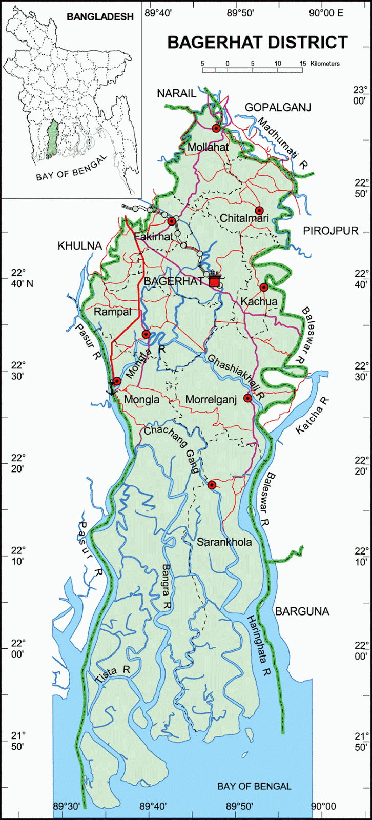
Political Map of Bagerhat District
Bagerhat District Map
বাগেরহাট জেলা মানচিত্র
(click the map for larger version)
Source:
http://www.banglapedia.org/httpdocs/HT/B_0032.HTM
Related post:
Khulna District Map
Narail District Map
Gopalganj District Map
Pirojpur District Map
Barguna District Map
Tuesday, October 26, 2010
Political Map of Satkhira District
Satkhira District Map
সাতক্ষীরা জেলা মানচিত্র
(click the map for larger version)
Source:
http://www.banglapedia.org
Related post:
Khulna District Map
Jessore District Map
Political Map of Khagrachhari District
Khagrachhari District Map
খাগড়াছড়ি জেলা মানচিত্র
(click the map for larger version)
Source:
http://www.banglapedia.org
Related Post:
Rangamati District Map
Chittagong District Map
Political Map of Bandarban District
Bandarban District Map
বান্দরবন জেলা মানচিত্র
(click the map for larger version)
Source:
http://www.banglapedia.org
Related Post:
Rangamati District Map
Chittagong District Map
Cox's Bazar District Map
Monday, October 25, 2010
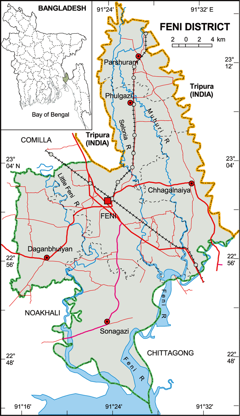
Political Map of Feni District
Feni District Map
ফেনী জেলা মানচিত্র
(click the map for larger version)
Source:
http://www.banglapedia.org
Related Maps:
Comilla District Map
Noakhali District Map
Chittagong District Map
Political Map of Noakhali District
Noakhali District Map
নোয়াখালী জেলা মানচিত্র
(click the map for larger version)
Source:
http://www.banglapedia.org
Related Maps:
Comilla District Map
Lakshmipur District Map
Feni District Map
Political Map of Lakshmiput District
Lakshmiput District Map
লক্ষীপুর জেলা মানচিত্র
(click the map for larger version)
Source:
http://www.banglapedia.org
Related Maps:
Chandpur District Map
Political Map of Chandpur District
Chandpur District Map
চাঁদপুর জেলা মানচিত্র
(click the map for larger version)
Source:
http://www.banglapedia.org
Related Maps:
Comilla District Map
Map showing Comilla, Brahmanbaria, Chandpur, Noakhali, Lakshmipur and Feni District
Map showing Comilla, Brahmanbaria, Chandpur, Noakhali, Lakshmipur and Feni District
কুমিল্লা, ব্রাহ্মণবাড়িয়া, চাঁদপুর, নোয়াখালী, লক্ষীপুর ও ফেনী জেলা মানচিত্র
(click the map for larger version)
Related Maps:
Comilla District Map
Brahmanbaria District Map
Chandpur District Map
Noakhali District Map
Lakshmipur District Map
Feni District Map
Sunday, October 24, 2010
Political Map of Habiganj District
Habiganj District Map
হবিগঞ্জ জেলা মানচিত্র
(click the map for larger version)
Source:
http://www.banglapedia.org
Related Post:
Maulavi Bazar District Map
Sylhet District Map
Koshorieganj District Map
Alternative Spelling: Hobiganj, Hobiganz, Hobi Ganj, Habi Ganj
Political Map of Sunamganj District
Sunamganj District Map
সুনামগঞ্জ জেলা মানচিত্র
(click the map for larger version)
Source:
http://www.banglapedia.org
Related Post:
Sylhet District Map
Habiganj District Map
Koshoreganj District Map
Alternative Spelling: Sunamganz Zela, Suman Ganj Jila, Sunamganj Zilla
Political Map of Kishoreganj District
Kishoreganj District Map
কিশোরগঞ্জ জেলা মানচিত্র
(click the map for larger version)
Source:
http://www.banglapedia.org
Related Maps:
Mymensing District Map
Saturday, October 23, 2010
Political Map of Madaripur District
Madaripur District Map
মাদারীপুর জেলা মানচিত্র
(click the map for larger version)
Source:
http://www.banglapedia.org
Related Post:
Faridpur District Map
Gopalganj District Map
Political Map of Gopalganj District
Gopalganj District Map
গোপালগঞ্জ জেলা মানচিত্র
(click the map for larger version)
Source:
http://www.banglapedia.org
Related Post:
Faridpur District Map
Narail District Map
Friday, October 22, 2010
Political Map of Faridpur District
Faridpur District Map
ফরিদপুর জেলা মানচিত্র
(click the map for larger version)
Source:
http://www.banglapedia.org
Related Post:
Gopalganj District Map
Madaripur Ditrict Map
Dhaka District Map
Narail District Map
Magura District Map
Manikganj District Map
Thursday, October 21, 2010
Political Map of Sitakundu Upazila
Sitakundu Upazila Map
সিতাকুণ্ডু উপজেলা মানচিত্র
(click the map for larger version)
Source:
http://www.banglapedia.org
Related Post:
Chittagong District Map
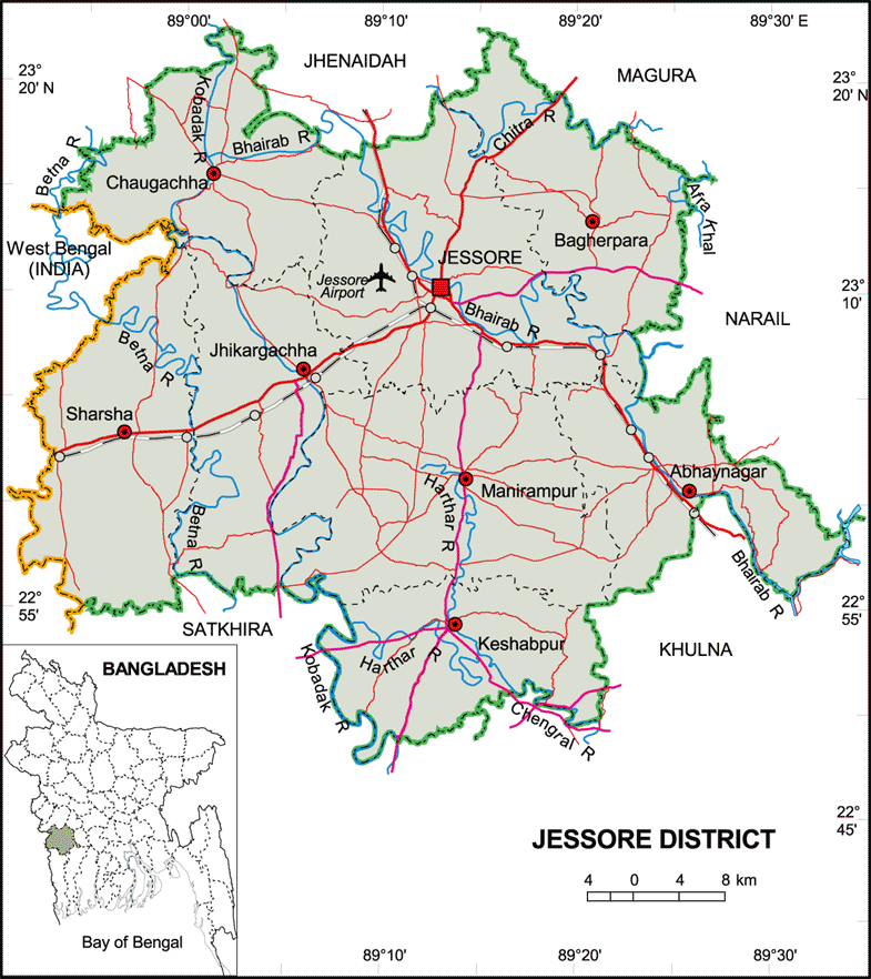
Political Map of Jessore District
Jessore District Map
যশোর জেলা মানচিত্র
(click the map for larger version)
Source:
http://www.banglapedia.org/httpdocs/HT/J_0093.HTM
Related Maps:
Jhenaidaha District Map
Magura District Map
Narail District Map
Khulna District Map
Political Map of Khulna District
Khulna District Map
খুলনা জেলা মানচিত্র
(click the map for larger version)
Source:
http://www.banglapedia.org/httpdocs/HT/K_0247.HTM
Related Maps:
Jessore District Map
Narail District Map
Wednesday, October 20, 2010
Political Map of Bogra District
Bogra District Map
বগুড়া জেলা মানচিত্র
(click the map for larger version)
Source:
http://www.banglapedia.org
Related Post:
Sirajganj District Map
Natore District Map
Political Map of Natore District
Natore District Map
নাটোর জেলা মানচিত্র
(click the map for larger version)
Source:
http://www.banglapedia.org
Related Post:
Pabna District Map
Sirajganj District Map
Bogra District Map
Rajshahi District Map
Political Map of Sirajganj District
Sirajganj District Map
সিরাজগঞ্জ জেলা মানচিত্র
(click the map for larger version)
Source:
http://www.banglapedia.org
Related Post:
Pabna District Map
Bogra District Map
Natore District Map
Tangail District Map
Jamalpur District Map
Political Map of Pabna District
Pabna District Map
পাবনা জেলা মানচিত্র
(click the map for larger version)
Source:
http://www.banglapedia.org
Related Maps:
Sirajganj District Map
Natore District Map
Tuesday, October 19, 2010
Political Map of Rangamati District
Rangamati District Map
রাঙ্গামাটি জেলা মানচিত্র
(click the map for larger version)
Source:
http://www.banglapedia.org
Related Post:
Chittagong District Map
Monday, October 18, 2010
Political Map of Cox's Bazar District
Cox's Bazar District Map
কক্সবাজার জেলা মানচিত্র
(click the map for larger version)
Source:
http://www.banglapedia.org
Related Post:
Chittagong District Map
Friday, October 8, 2010
Political Map of Gazipur District
Gazipur District Map
গাজীপুর জেলা মানচিত্র
(click the map for larger version)
Source:
Banglapedia
Related Post:
Dhaka District Map
Tangail District Map
Mymensing District Map
Gazipur Sadar Upazila Map
Kapasia Upazila Map
Kaliakair Upazila Map
Kaliganj Upazila Map
Sreepur Upazila Map
Alternative Spellings/Names:
Gazipur Zila, Gajipur, Gazipur Zela, Gajipur Jela, গাজিপুর
Political Map of Bhaluka Upazila
Bhaluka Upazila Map
ভালুকা উপজেলা মানচিত্র
(click the map for larger version)
Source:
www.banglapedia.org
Related Post:
Map of Mymensing District
Alternative Spellings/Names:
Valuka, Valuka Thana
Newer Posts
Older Posts
Home
Subscribe to:
Posts (Atom)