Google AdSense Code

Wednesday, April 15, 2020

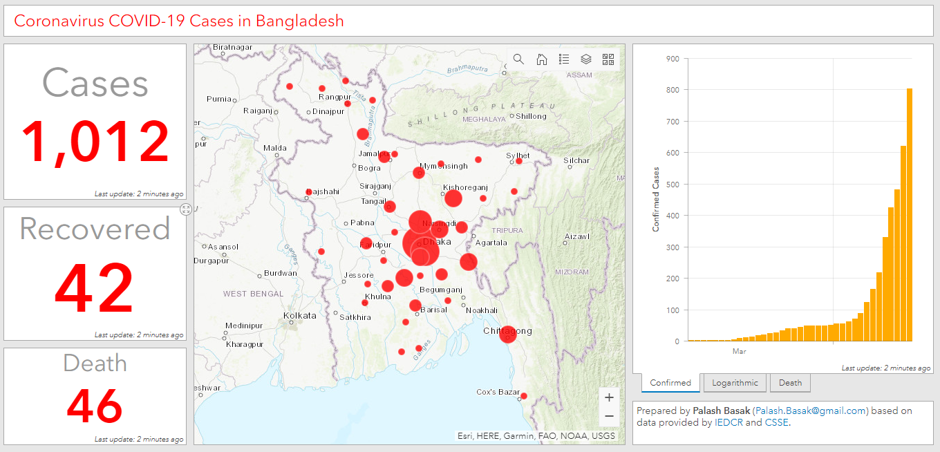
The total number of coronavirus COVID-19 cases in Bangladesh has crossed 1,000-mark. Find an updated ArcGIS dashboard for the country with graphs, maps, and time series.

https://arcg.is/SLmTm

With Faridpur in the list, all districts in the Dhaka division are now infected with the virus. Dhaka division contains 820 cases in its boundary, which is over 80% of the national total. Approximately 45% of the cases (456) are just in Dhaka city. Cases in Dhaka, Narayanganj, and Gazipur districts are increasing at a faster pace.


Fresh cases have been observed in Khulna and Narail district. With that, three districts under the Khulna division are now under the attack of coronavirus. Except for the Rajshahi district, the rest of the Rajshahi division is still free from coronavirus. No cases have been recorded yet in the hill-tract areas under the Chittagong division.

Click the dots on the map for time series data. Zoom in to show the number of cases in each district.

Sunday, April 12, 2020

Coronavirus COVID-19 Cases in Bangaldesh by District (as of 12 Apr 2020)


Coronavirus COVID-19 Cases in Bangladesh by District

The number of cases in Dhaka has crossed 300-mark while that in Narayanganj has crossed 100-mark. Fresh cases have been observed in Jhalokathi (3), Thakurgaon (3), Lalmanirhat (1), and Lakshmipur (1) districts.

Till now almost 90% of the cases are concentrated in the Dhaka division. However, cases are steadily spreading in Chittagong, Mymensing, Rangpur and Barisal Division. All districts in Rajshahi division are free from COVID-19 cases.

Monday, July 22, 2019

Bangladesh flood 2019: As seen from Sentinel-1 radar satellite

A significant flood is happening in Bangladesh. In this map red areas correspond to flood as of 19 Jul 2019.  As you can see, a significant portion of Jamalpur and Tangail districts have been flooded in the last few weeks.


Feel free to share and use the map I have created. Download/view higher resolution version of the map using the links below.

PNG: 

KMZ (need Google Earth to open the file): 

#FloodInBangladesh

Monday, December 5, 2016

Vegetation Index of Bangladesh - 2016

This map is showing normalized vegetation index (NDVI) of Bangladesh which was calculated from red and infrared bands of 14 Landsat 8 satellite images. These images were captured in between 12 to 23 November 2016.

The dark green areas in the map are forests or water-logged agricultural land; next level of dark green areas are rural settlements. Rest of the green areas are agricultural areas. Urban areas, water-bodies, and sandy areas are brown in color.


Find high resolution version of the map in this link.

Related map:
Satellite Image of Bangladesh - 2016
Satellite Image of Bangladesh
Night Lights of Bangladesh - 2012

Sunday, December 4, 2016

2016 Satellite Image View of Bangladesh - as seen by Landsat 8 satellite

November is one of the months when there is less cloud in the sky of Bangladesh. During this time optical satellites can see through most part of the country. The view below was captured by Landsat 8 satellite during November 2016. It is showing natural color view of Bangladesh, and it is a combinations of bands 4 (red), 3 (green), and 2 (blue) of the Landsat 8 satellite image. You can download or view higher resolution version of the image from this link.

Generated from Landsat 8 satellite images captured during November 2016
Natural color view of Bangladesh generated from Landsat 8 satellite images captured during November 2016. In this view, vegetation is shown in dark green, and water body is shown as light blue color.

The natural color view of the country is improvised with another color combination of the satellite image. The image below shows the combination of bands 7 (short-wave infrared - 2), 5 (near infrared), and 3 (red). In this view, atmospheric disturbances have been removed. You can download or view higher resolution version of the image from this link.

Natural color view of Bangladesh without atmospheric disturbances generated from Landsat 8 satellite images captured during November 2016. In this view, vegetation is shown in light and dark green, and water body is shown as blue color. Urban areas and sandy areas shown in purple color.
To generate the views, it was required to stitch together fourteen (14) Landsat 8 images which were captured in between 12 and 23 November 2016.

Related map:
Vegetation Index of Bangladesh - 2016
Satellite Image of Bangladesh
Night Lights of Bangladesh - 2012

Friday, December 19, 2014

Dhaka - Thana map

Dhaka - Thana Map


Original shapefile was downloaded from http://gdi.geo.hu-berlin.de/details.php?uuid=20121221-13272300

Saturday, January 26, 2013

Night Lights of Bangladesh - 2012

Night Lights of Bangaldesh 2012


The original image was taken by the Suomi National Polar-orbiting Partnership (Suomi NPP) satellite in any day between April 2012 and October 2012, and has been taken from NASA's Earth Observatory website (Night Lights 2012 - Flat map). This map has been created by annotating the original image in Google Earth (with international boarders) and Power Point (labels).

Related Map: 
Road Network of Bangladesh

Thursday, August 30, 2012

Saturday, June 18, 2011

Political Map of Ajmiriganj Upazila - Habiganj District

Ajmiriganj Upazila Map - Habiganj District
আজমিরিগঞ্জ উপজেলা মানচিত্র - হবিগঞ্জ জেলা
(click the map for larger version)

Friday, June 17, 2011

Political Map of Bahubal Upazila - Habiganj District

Bahubal Upazila Map - Habiganj District
বাহুবল উপজেলা মানচিত্র - হবিগঞ্জ জেলা
(click the map for larger version)