Maps of Bangladesh
Political, Physical, Geological, Archeological and other types of map of Bangladesh.
Google AdSense Code
Friday, October 29, 2010
Political Map of Barisal District
Barisal District Map
বরিশাল জেলা মানচিত্র
(click the map for larger version)
Source:
http://www.banglapedia.org
Related Post:
Patuakhali District Map
Pirojpur District Map
Barguna District Map
Thursday, October 28, 2010
Political Map of Phulbari Upazila, Dinajpur
Phulbari Upazila Map
ফুলবাড়ী উপজেলা মানচিত্র
(click the map for larger version)
Source:
http://www.banglapedia.org
Related post:
Dinajpur District Map
Political Map of Dinajpur District
Dinajpur District Map
দিনাজপুর জেলা মানচিত্র
(click the map for larger version)
Source:
http://www.banglapedia.org
Related post:
Panchagarh District Map
Political Map of Panchagarh District
Panchagarh District Map
পঞ্চগড় জেলা মানচিত্র
(click the map for larger version)
Source:
http://www.banglapedia.org/httpdocs/HT/P_0057.HTM
Related post:
Dinajpur District Map
Nilphamari District Map
Thakurgaon District Map
Wednesday, October 27, 2010
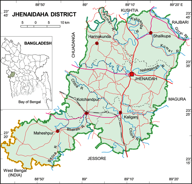
Political Map of Jhenaidah District
Jhenaidah District Map
ঝিনাইদহ জেলা মানচিত্র
(click the map for larger version)
Source:
http://www.banglapedia.org
Related post:
Jessore District Map
Magura District Map
Political Map of Bagerhat District
Bagerhat District Map
বাগেরহাট জেলা মানচিত্র
(click the map for larger version)
Source:
http://www.banglapedia.org/httpdocs/HT/B_0032.HTM
Related post:
Khulna District Map
Narail District Map
Gopalganj District Map
Pirojpur District Map
Barguna District Map
Tuesday, October 26, 2010
Political Map of Satkhira District
Satkhira District Map
সাতক্ষীরা জেলা মানচিত্র
(click the map for larger version)
Source:
http://www.banglapedia.org
Related post:
Khulna District Map
Jessore District Map
Political Map of Khagrachhari District
Khagrachhari District Map
খাগড়াছড়ি জেলা মানচিত্র
(click the map for larger version)
Source:
http://www.banglapedia.org
Related Post:
Rangamati District Map
Chittagong District Map
Political Map of Bandarban District
Bandarban District Map
বান্দরবন জেলা মানচিত্র
(click the map for larger version)
Source:
http://www.banglapedia.org
Related Post:
Rangamati District Map
Chittagong District Map
Cox's Bazar District Map
Monday, October 25, 2010
Political Map of Feni District
Feni District Map
ফেনী জেলা মানচিত্র
(click the map for larger version)
Source:
http://www.banglapedia.org
Related Maps:
Comilla District Map
Noakhali District Map
Chittagong District Map
Political Map of Noakhali District
Noakhali District Map
নোয়াখালী জেলা মানচিত্র
(click the map for larger version)
Source:
http://www.banglapedia.org
Related Maps:
Comilla District Map
Lakshmipur District Map
Feni District Map
Political Map of Lakshmiput District
Lakshmiput District Map
লক্ষীপুর জেলা মানচিত্র
(click the map for larger version)
Source:
http://www.banglapedia.org
Related Maps:
Chandpur District Map
Newer Posts
Older Posts
Home
Subscribe to:
Posts (Atom)